2.6 magnitude earthquake detected near El Hierro
- 17-02-2025
- National
- INVOLCAN .
- Photo Credit: IGN
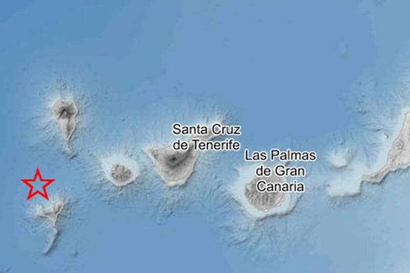
The National Geographic Institute (IGN) have reported the detection of a 2.6 magnitude earthquake near the municipality of Frontera, El Hierro, during the early hours of this morning (Monday).
According to their report, the tremor occurred at 1:28am, at a depth of 29 kilometres, and so far, the IGN has not confirmed whether the seismic event was felt by the local population.
Seismic activity in El Hierro is significant due to its volcanic origins and ongoing geodynamic processes. As the youngest and smallest of the Canary Islands, El Hierro sits above a volcanic hotspot, making it prone to frequent tremors and occasional eruptions.
One of the most notable examples of this occurred in 2011 when an underwater eruption took place south of the island following months of intense seismic swarms. These tremors serve as important indicators of magma movement beneath the surface and help scientists monitor potential volcanic activity.
The island's seismic activity also provides insight into tectonic movements and island formation. The Canary Islands have developed through a combination of volcanic activity and mantle plume dynamics, and the earthquakes recorded in El Hierro are a sign of ongoing geological processes. As magma shifts beneath the island, it can lead to eruptions, ground deformation, and even the potential for new land formation.
The island’s seismic activity also offers valuable opportunities for scientific research. El Hierro serves as a natural laboratory for studying volcanic and seismic processes, helping researchers better understand magma dynamics, geothermal energy potential, and eruption forecasting. The data collected from seismographs and GPS stations contribute to broader studies on how volcanic islands evolve over time.
Other articles that may interest you...
Trending
Most Read Articles
Featured Videos
TributoFest: Michael Buble promo 14.02.2026
- 30-01-2026
TEAs 2025 Highlights
- 17-11-2025


