Weather warnings are activated in all of the Canary Islands until the weekend


The State Meteorological Agency (AEMET) has extended the yellow weather warnings it issued yesterday (Tuesday), but not only are they extended until the weekend, but they have now issued two different warnings for strong winds and waves, that affect the entire archipelago.
This means the following alerts are in place for each island:
TENERIFE:
A warning for strong winds comes into effect from 6:00pm tomorrow (Thursday) and will last, in principle, until 6:00am on Friday. It is expected to affect the east, south, and west of the island, where there will be maximum gusts of up to 70 km/h. The wind will blow from the northeast, mainly affecting high areas and southeast and northwest slopes.
The warning for coastal phenomena (swells) starts tonight at 8:00pm (Wednesday) and will also be in force until 6:00am on Friday. All coasts of the island will be affected, with a swell of between 4 and 5 metres is expected, and a force 7 north-easterly wind (between 50 and 61km/h) in the southeast of the island.
GRAN CANARIA:
A warning for strong winds comes into effect from 6:00pm tomorrow (Thursday) and will last, in principle, until 6:00am on Friday. It is expected to particularly affect the east, south, and west of the island, where there will be maximum gusts of up to 70 km/h. The wind will blow from the northeast, mainly affecting the summits.
The warning for coastal phenomena (swells) starts tonight at 8:00pm (Wednesday) and will also be in force until 6:00am on Friday. All coasts of the island will be affected, with a swell of between 4 and 5 metres is expected.
LANZAROTE:
Only one warning is active in Lanzarote for coastal phenomena (swell), which came into effect at 3:00pm this afternoon (Wednesday), until 6:00am on Friday. The east and west coasts will be affected, where a combined northerly swell of 4 to 5 metres is expected.
FUERTEVENTURA:
A warning is active for coastal phenomena (swell), which also came into effect at 3:00pm this afternoon (Wednesday), until 6:00am on Friday. The east and west coasts will be affected, where a combined northerly swell of 4 to 5 metres is expected.
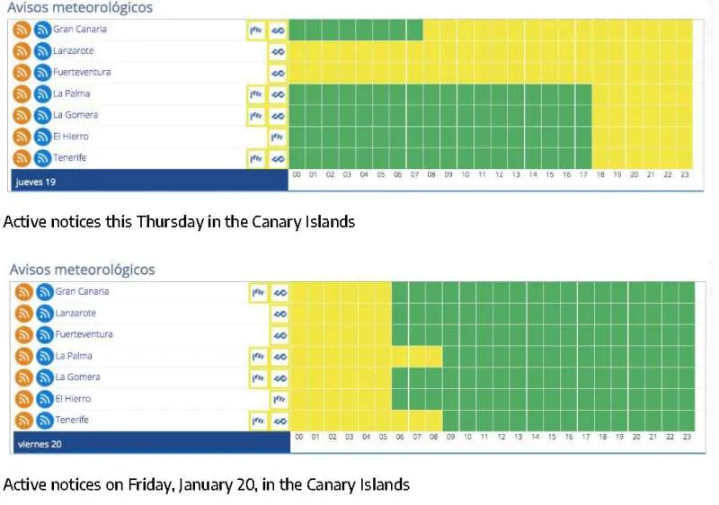
LA PALMA:
There is a warning for strong winds that comes into effect from 6:00pm tomorrow (Thursday) and will last, in principle, until 6:00am on Friday. It is expected to affect the summits and west of the island, where there will be maximum gusts of up to 70 km/h. The wind will blow from the northeast, particularly affecting high areas and southeast and northwest slopes.
The warning for coastal phenomena (swells) starts tonight at 8:00pm (Wednesday) and will also be in force until 9:00am on Friday. The east and west coasts will be affected, where a combined northerly swell of 4 to 5 metres is expected.
LA GOMERA:
It has a warning for strong winds that comes into effect from 6:00pm tomorrow (Thursday) and will last, in principle, until 6:00am on Friday. It is expected to affect the summits and west of the island, where there will be maximum gusts of up to 70 km/h. The wind will blow from the northeast, particularly affecting high areas and southeast and northwest slopes.
The warning for coastal phenomena (swells) starts tonight at 8:00pm (Wednesday) and will also be in force until 6:00am on Friday. The east and west coasts will be affected, where a combined northerly swell of 4 to 5 metres is expected.
EL HIERRO:
El Hierro only has one warning for strong winds that comes into effect from 6:00pm tomorrow (Thursday) and will last, in principle, until 6:00am on Friday. It is expected to especially affect the summits and west of the island, where there will be maximum gusts of up to 70 km/h. The wind will blow from the northeast, especially affecting high areas and southeast and northwest slopes.
Share: