
The Canary Islands have alerts for wind, snow, rain and storms this Sunday

The Canary Islands are set to experience a bout of adverse weather tomorrow, Sunday, with warnings in place for strong winds, heavy rain, snowfall, and thunderstorms, according to the State Meteorological Agency (AEMET).
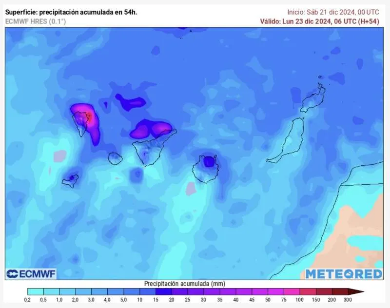
Intense rainfall is forecasted for Lanzarote and Fuerteventura, while moderate rain is expected in the northern regions of the mountainous islands.
Snow is anticipated on Mount Teide, and temperatures are set to drop. Winds will blow from the northeast, ranging from moderate in the eastern islands (Lanzarote and Fuerteventura) to strong in Tenerife and the western ones.
AEMET has also warned of potentially very strong gusts of wind in the southeastern and northwestern slopes of the western islands, with strong northeast winds and a likelihood of very strong gusts.
Sea Conditions and Coastal Warnings
Maritime conditions are also expected to be rough, with northeast winds reaching force 5 to 6 and strengthening to force 7 offshore. This will result in choppy seas, with swells ranging from rough to very rough. The western, southern, and southwestern coasts will have calmer conditions with variable winds of force 1 to 3.
Rain showers, reduced visibility, and poor conditions at sea are expected, especially from the early hours of Sunday morning.
Pre-alerts Issued for Rain and Coastal Phenomena
The Canary Islands Government have updated and expanded the pre-alert status for rain to cover all of the islands. This pre-alert applies to the northern slopes and summits of El Hierro, La Gomera, Tenerife, and Gran Canaria, as well as the northern, eastern, and summit regions of La Palma, Fuerteventura, and Lanzarote.
Rainfall is expected to range from light to moderate, with localised intense showers and possible thunderstorms. In La Palma and Tenerife, rainfall accumulation over 12 hours is predicted to reach or exceed 60mm.
Additionally, a pre-alert for adverse coastal phenomena has been declared from midnight on Sunday. This affects the northern and western coasts of La Palma, El Hierro, La Gomera, Fuerteventura, and Lanzarote, as well as the northern coastlines of Tenerife and Gran Canaria. The decision follows information from AEMET and other meteorological sources under the Canary Islands’ Specific Emergency Plan for Adverse Meteorological Risks (PEFMA).
Weather Island by Island
LANZAROTE
Cloudy skies will bring moderate rain, potentially intense during the morning, with a chance of small hail and isolated thunderstorms. Conditions will clear later in the day, with light dust haze possible by evening. Temperatures will dip slightly, ranging between 13°C and 20°C, and moderate northeast winds may turn easterly by midday.
FUERTEVENTURA
Similar to Lanzarote, moderate rainfall, occasional hail, and thunderstorms are expected in the morning. The weather will become clearer by the afternoon, with light dust haze possible in the evening. Temperatures will see a slight decline, with lows of 14°C and highs of 20°C.
GRAN CANARIA
Northern and interior areas will have overcast skies with moderate rain, locally intense during the morning. Other regions may see less cloud cover and isolated light rain. Temperatures will remain steady with slight drops overnight. Temperatures will be between 15°C and 21°C. Northerly winds will be strong in higher altitudes with gusts easing later in the day.
TENERIFE
Northern regions and higher elevations will experience cloudy skies with moderate rain, while Mount Teide may see snow above 2,000–2,200 metres. Elsewhere, light rain is possible in the east and southwest. Temperatures will drop slightly, with lows of 16°C and highs of 21°C. Strong northeast winds, with very strong gusts in specific areas, are forecast, particularly in high altitudes.
Share:


