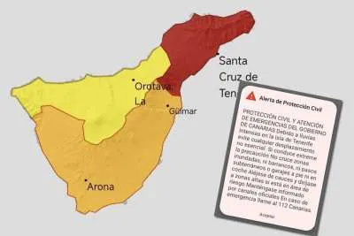
May surprises AEMET with 116% of expected precipitation in the Canary Islands
- 07-06-2024
- National
- AEMET .
- Photo Credit: CW
The Canary Islands experienced an unexpectedly wet May, with precipitation levels reaching 116% of the anticipated average, according to the State Meteorological Agency (AEMET). Despite May usually being a drier month, this year's rainfall far exceeded expectations.
AEMET's monthly report describes May as "pluviometrically wet," attributing the majority of the rainfall to a single significant event that occurred between May 14th and 20th.
During this period, the Atlantic high-pressure front was positioned northwest of the Azores, directing a northerly flow over the Canary Islands. This brought cooler, moister air masses, increasing the humidity layer over the islands and leading to heightened instability and subsequent rainfall.
Aside from the primary rain event, additional, more scattered and lighter showers were attributed to cloud accumulation. These were driven by the occasional passage of moist air masses, brought about by the prevailing Tradewinds affecting the northern slopes of the more mountainous islands.
Temperature Trends
Regarding temperatures, May's average in the Canary Islands was 18.6°C, which represents a positive anomaly of +0.7°C, classifying the month as "warm”. This temperature anomaly placed May 2024 as the 12th warmest May recorded in the archipelago since 1961.
In terms of accumulated precipitation, the average was 5.7 litres per square metre, ranking this May as the 23rd wettest since records began in 1961.
This data highlights the unusual climatic patterns experienced in the Canary Islands this past May, emphasising the variability and unpredictability of weather in the region.
Other articles that may interest you...
Trending
Most Read Articles
Featured Videos
TributoFest: Michael Buble promo 14.02.2026
- 30-01-2026
TEAs 2025 Highlights
- 17-11-2025


