
Monday Weather: These are the active yellow warnings in the Canary Islands

The Canary Islands continue to be under yellow weather warnings today, Monday, due to ongoing effects of Storm Martinho, with all islands except Fuerteventura at risk from high winds or coastal phenomena, according to Spain’s national weather agency, AEMET.
La Palma, El Hierro, La Gomera, Tenerife and Gran Canaria are expected to experience wind gusts reaching up to 70 km/h, with La Gomera possibly facing locally stronger gusts exceeding 90 km/h.
In addition to wind warnings, yellow alerts for rough seas are in place for Tenerife, Gran Canaria and Lanzarote.
AEMET forecasts north-easterly winds of 50 to 61 km/h (force 7 on the Beaufort scale) particularly affecting the southeast of Tenerife, the west and southeast of Gran Canaria, the Anaga-Agaete channel, and the southwest region from Jandía to La Isleta.
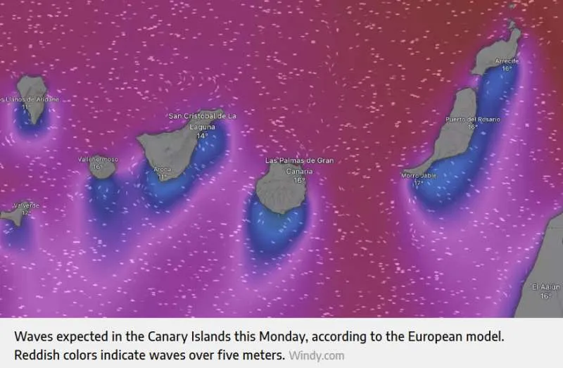
The expected sea conditions show waves potentially exceeding five metres in some areas, as illustrated by European weather models, and the public are urged to exercise caution if sunbathing or walking along exposed coastlines.
Video of waves in La Gomera this weekend. Courtesy of GCTV:
Meanwhile, although Storm Martinho is gradually moving away from mainland Spain, its remnants will continue to bring unsettled weather. Overcast skies and rain are expected across the northern half of the country, with significant snowfall likely in mountain regions, particularly in the Cantabrian range, the Iberian system and eastern parts of the Central system. Isolated snowfall may also reach the eastern Meseta.
Persistent rain is forecast for the Cantabrian coast, and locally heavy showers with thunderstorms and possible hail are expected in the Balearic Islands.
In the Canary Islands, northern areas of the islands may see light rain under mostly cloudy skies, while southern zones are expected to remain clearer.
The broader weather pattern will begin to stabilise as low pressure shifts towards the Gulf of Genoa and high-pressure systems advance from the west. Trade winds will dominate, with intervals of strong gusts, especially in exposed areas, mountain peaks and wind channels.
Share:


